Friday, February 25, 2011

Spanish Auschwitz in Bolivia! (20-23 February 2011, Days 72-75 of 127)

The cities of Potosi and Sucre in Bolivia are bitter-sweet!

Potosi has a dark and inhuman past as the "Auschwitz" of Bolivia perpetrated by the Spanish conquerers but Sucre is the city where the local hero Simon Bolivar signed a petition liberating, was is today six South American countries, from Spanish rule. More on this later.

It is official! The current Bolivian Consitution states "Sucre is the capital of Bolivia", even though the President and all government ministries are located in La Paz. If La Paz was the capital then it would have been the highest capital city in the world but sadly it is not. It is not even the highest city in the world as I advised previously owing to a technicality. La Paz is often called the highest city because it has a suburb that reaches 4,100m but its central plaza is at 3,660m making its average elevation at 3,800m. It is the "average" elevation that counts. Potosi (featured in this blog) is officially the highest city since its average elevation is 4,090m.

The journey from La Paz to Sucre took 12hrs on the bus and 14hrs hotel-to-hotel. Our Intrepid family also expanded from 4 to 10 with Michael from Melbourne (my new room mate for the next 17 nights to Santiago), Melaney/Joe/Clare from Sydney, Amanda from London and Megan from Joannesburg. My 83-day Intrepid journey from Quito (Dep 14JAN11) to Rio (9APR11) is actually five separate Intrepid tours strung back-to-back. Only Maureen and I are on all of them. In La Paz on 18FEB, we started tour number 3 of the 5 Intrepid tours - this is why we added another 5 people. Our guide also changed. We farewelled Ali-Jei and took on Carlos, born and bred in La Paz, Bolivia. Carlos is with us for tours number 3 and 4 through to Santiago then Buenos Aires.

Once we dumped our stuff at 8:30am in our hotel in Sucre (Pop 215,800. Elev 2,750m. Est 1538), we all walked to the town central plaza and had breakfast. After this I was off on my own to discover the city. First stop the mandatory cathedral and central plaza. The cathedral interior is mainly granite and gives off a pale olive colour when photographed. The central "Plaza 25 De Mayo" is adourned with many gardens and two fountains and a statue of General Jose De Sucre, the guy who lead the 15yr revolution that led to independence in 1825.

There is a musuem on the plaza that contains the location and document that Simon Bolivar signed with the Spanish, marking not only the independence of Bolivia, but also of Equador, Peru, Columbia and Venezuela - what a guy - no wonder his name is everywhere! Bolivar then ordered the city buildings to be "whitewashed" to symbolise the new republic and these remain to this day with Sucre known as the "White City". I then walked up a hill to Plaza Anzures overlooking the city and decided to go higher - up a mountain behind with a Madonna on the top. I stopped half-way up since the hill is covered in Eucalyptus trees which obscure the splendid view of the city. Next stop was the markets where I bought all my souvenirs for lower prices than in La Paz and all pure Alpaca - no nylon!

I then returned to the hotel, had a shower and relaxed in the TV room assembling and posting the post before this one. Sucre has the cleanest shoes of all - there are shoe-shine people everywhere - as well as internet cafes.

At 6pm, Michael and I decided to attend Catholic Mass at the central cathedral as a means of getting closer to the locals. Michael, a practicing Catholic, was also curious to see how the service compared to those in Oz. After our arrival at the church we discovered that there is no service at the central cathedral but there is one at San Francisco Church near the markest at 7pm. So we went off for a quiet glass of wine and chat in a cosy bar on the plaza. Turns out that Michael spent 20yrs organising Tennis sponsorships for Rado and then Rolex, part-time, as well as his full-time job in HR for the Vic Gov IT department.

The service at the Church of San Francisco was an incredible surprise for both of us. Instead of a choir was a teenage rock-band complete with lead and bass guitar, drums and singers. A huge sheet was suspended above the alter with the words of hymns projected on it. The priest looked late 20s, early 30s, clapping his hands and the congregation was mainly young people. What a surprise. According to Michael, the hymns and order of service are the same as in Oz but the melodies are different. After an extra long homily, Michael had communion (I already had mine at the hotel!!!) and we set off for Alexander Cafe, where our guide organised a special dinner. Intrepid sponsors projects all over South America to benefit locals. In this case, 11 teenage orphans were cooking and serving dinner. We had enchaladas and plenty of beer! Profits went to the orphanage. After dinner, I was too embarrased to declare my hunger to the kids so I raced off to the local supermarket for a top-up over a cable movie at the hotel. I didn't even remember falling asleep!


I awoke on the 21FEB in a trance but felt very rested. Enough to tackle a 10km run through the streets of the capital. This time the chasing dogs got a bit too close - I felt a lick and hot breath on my shin before the owner ran out and threw a pipe at the dog! All I could do was keep my track and pace, not make eye contact with the hound of hell and shout "Amigo"!!!


After a cool shower I was ready to tackle the dinosaur footprints, 10km from the city. It turns out that a concrete company found 5,000 footprints in 1985 when they mined an entire hill. The company stopped the mining at that hill and built the "Cretaceous Park" complex in 2007 on the opposite peak. A truck with wooden seats and a plastic rain cover took us out there from the Plaza at noon. On arrival, we were assigned a local English-speaking guide who took us through the complex. The prints were made by 4 groups of dinosaurs approx 60 million years ago. They estimate up to 400 different types of dinosaurs made these prints but it is hard to confirm since it is hard to differentiate tracks made within each of the four groups and no complete skeletons have been found. The complex also has life-size replicas of many dinosaurs suspected of making the tracks including a T-Rex, giant Brontosaurus and Tricerotops. You stand on a platform and view the tracks on the half-cut hill some 200m away and can pay more for the provided telescopes. You can see the tracks with the naked eye but it would have been better to walk to the base of the hill to get a closer view.


By 2:30pm I was back in the central plaza and hit the hotel to download a virus software for my laptop and start this post. Dinner tonight was at a local family run "hole in the wall", one of very many in Sucre and recommended by Carlos. Soups here were $AUD1.10 and mains only $AUD1.90. Ridiculous!

The 22FEB began with a second run in Sucre followed by a little more shopping including the replacement of USB07 which suffered a virus attack and would not store any MOV files. Finally I was able to load a light-weight virus software and get rid of the heavier software loaded in Puno by the guys who brought my little laptop back to life. Then it was off to Potosi by 4 taxis, leaving at 2pm. The total 162km trip took 3hrs.

Potosi (Pop 149,200. Elev 4,090m. Est 1545) is the highest city in the world and UNESCO protected because of its silver mining history and the attrocites that occurred here at the hands of the Spanish. Potosi also has the world's 7th highest airport.

The Spanish forced millions of indigenous peoples and slaves from Africa to work in the mines of Cerro Rico (Mt Rico) which overlooks the city. These poor souls were forced to work in the mines for up to 6mths without coming out, living on just coca leaves, rice and water. The temperature in these mines varied from 35-45C with humidity, little air, noxious sulphur fumes and worse of all, silica dust causing most to die of silicosis at age 45. It is estimated that up to 8 million people died under these conditions over a 300 year period. Ironically during this period, Potosi became one of the wealthiest cities in the world with silver lined pavements and all silver going back to Spain to fund their wars and conquests over this 300 year period. Tragically the mines of Potosi in Cerro Rico still exist and the whole town engages in this single activity but the yield is very low with some silver but mainly tin and lead. Potosi is now one of the world's poorest cities and is likely to become a ghost town when the mine runs out. The indigenous work the mines because they have no other options and most die of silicosis by age 45. The next day, 23FEB, we experienced these working mines, first hand, by taking one of many tours to the mine.


We left at 8:30am in a van and travelled close to the outskirts of Potosi where we changed into mining gear complete with hard hat and light. We then visited the local markets to buy the miners some presents such as drinks, smokes, coca leaves and even dynamite (for exploding inside the mine!). After we all got to hold the dynamite (but not light it) we travelled to the mine entrance itself, roughly one-third of the way up Mt Rico (at a height of approx 4,200m).

Nine of us then proceeded into the darkness of the mine with ex-miners at the front and rear. After two bouts of crawling and 30min of walking we came into the main section of level 1. We were coughing constantly because of the Sulphur and dust and we could barely breath the hot, humid air, what little there was of it. Seven of us, including me, decided to call it quits as our guides wanted to take us down to levels 2 and 3 to meet working miners. This was another 30min of crawling and whilst I was OK to do it, it was not enjoyable and I wanted to conserve my energy for my record breaking run in the world's highest city! Before we turned around, our miner guide explained the attrocities that had occurred in this very place we were sitting and the working conditions of miners today. He also explained the effigy of the Devil (Tio) in the chamber with us, adorned with offerings of coca leaves, beer and smokes so that he would not attack the miners and give them a good yield. We couldn't stand just 60min of being here.... imagine being down here for 6mths - it is simply incomprehensible and many respects, worse than the conditions even in Auschwitz! Refer POTOSI MINE FACTS below for more stats on this gruesome place. Indeed, the Spanish Auschwitz of Bolivia and in some respects even today.
On our way back from the mines a bunch of youths attacked our van (banging their fists on the windows) as we were coming down a narrow street close to the hotel. The driver locked us inside and proceeded outside to find out what was going on. It turns out that he was not allowed to drive a tourist van down that street. We never found out who the youths were but after letting out the air from our tyres, our driver brought us safely to the hotel! Our first real drama!

Johnny Cloudrunner does it again! At exactly 2:35pm on Wednesday 23 February 2011 after my return from the mines, I successfully completed a 10km run of Potosi in 55min breaking all previous altitude records (the last being Titicaca at 3,809m) by running at 4,090m (13,426ft) which is only 547ft under the oxygen line!!! It was the hardest run to date since Potosi is a hilly place and I copped a 4km hill, 5min of hail and the rest in rain at 13C. I was soaked, cold and buggered when I got back but did not stop and managed a 5.5min/km pace. I was elated.

I then met Maureen and Michael to tour the famous "Casa Nacional De Moneta" or "Mint Musuem". Our 90min English tour started and 4:30pm and chronicalled the complete history of Silver and coin-making in Potosi, including real equipment used and many samples of coins and silver treasures. Coins were made in Potosi for both Bolivia, South America and Spain from 1575 to 1951. Bolivia's current coins are made in Chile.

To celebrate my run, Maureen, Poonan and I cooked a big fat Vegetable Fettuccine with loads of garlic and chillie and tons of Bolivian white which we shared with 4 others! We all then watched a film called "The Miner's Devil" made in 2005 by a German director here in Potosi, telling the story of two 12 and 15 yr old brothers working in the mines. This film is acclaimed and won many European and American film awards (not an Oscar). The film was well shot and very confronting and the two boys it featured are now 19 and 21 and sadly still working in the mines!

NEXT BLOG: to cover the Uyuni Salt Flats and the exit from Bolvia due 1MAR.

POTOSI MINE FACTS: 1) 12,000 men and boys (youngest 13, eldest 65) currently work in the Potosi mine of Cerro Rico. 2) The miners are part of a co-operative and work for themselves. They can work as long or short as they want but must pay 15% of their income to the coop so that it can maintain the mine complex and provide compressed air for breathing and jack-hammers. 3) Collectively they mine 2,000 tons of raw material each month. From this a typical yield is just 500kg of silver worth 700-800B ($AUD100-120). Miners can get higher yields up to 3,000B ($AUD430) per month but the hours are long or they got lucky with purity. 4) Miners must pay private trucks to take their raw material to one of 37 privately owned processing plants in the area. Here, silver, lead or tin ore is extracted from the raw material and sold to other private companies in Chile and Argentina, who in turn sell the ore to Japan and China for smelting into the pure metal for use in manufacture. 5) Most of today's miners die of silicosis or cave-ins caused by bad dynamite detonations. There is no regulation or safety of mining activity here. In 2010, the death toll was 25 and in 2009 it was 40, considered low and normal, respectively. 6) Many children aged 13-17 continue to work in the mines. No women are allowed to work in the mines due to superstitious belief that they bring bad luck.

MORE BOLIVIA FACTS: 1) Bolivia and Peru cities are full of mini-vans carrying between 10-20 people. This is because public buses are too infrequent and slow and for the average person, taxis are too expensive. These vans are everywhere, produce noxious diesel fumes (since noone bothers maintaining them) and they pull over all the time to pickup/setdown people. They are the number one obstacle for me when I run in these cities. Average fare on these is $AUD0.30 versus $AUD0.10 on the bus and $AUD1.00 in the taxi.

Monday, February 21, 2011

City in the Clouds (15-19 February 2011, Days 67-71 of 127)

Our journey from Puno in Peru to Copacabana in Bolivia, both on Lake Titicaca, took a total of 5.5hrs, 3 of those on the bus and the rest at the border posts of the two countries.

The border posts were as inefficient as the ones I experienced in Peru, Chile and Agentina with only one person on duty!

Copacabana (Pop 54,300, Elev 3,809) is a very relaxing small town on the shores of Lake Titicaca.

It is quite grubby with bad roads but its main plaza and size make it easy to walk. There are tourists everwhere since this is the base for visiting the Isla Del Sol (birthplace of the Incan Sun God) and Isla Del Luna, another key Inca site.

On arrival at 12:30pm, I went for another record breaking run (my third around Lake Titicaca at 3,809m) since the weather was gorgeous with full sun, deep blue skies and crystal clear waters. I then set off to discover this little town with the famous name.

My first stop was to climb the hundreds of steps to the summit of Cerro Calvario (Calvary Mountain), Elev 3,966m which overlooks the city and bay with spectacular mouth-dropping views of Copacabana town and across Lake Titicaca to Isla Del Sol.

It is so-called after the place where Christ was crucified and features 14 stations of the cross on the way up. The experience at the top was superb. A cool breeze with shimmering lake waters, warm sun and deep blue sky with wispy clouds. The birds were out in force and after snapping a few photos I just sat there and soaked in the atmosphere (at almost 4,000m)! It was one of the most relaxing and inspiring moments of my journey to date.

After my descent I headed to the main plaza to see the Cathedral which is famous for its size and style and the icon of the "Black Virgin" which is supposed to be miraculous. This one of the most colourful churches I have seen - refer photo. It is huge and the style inside is like the Portuguese churches - deep blues and oranges on the arches with blue porcelain tiles.


I then walked down the main street connecting the main plaza (and church) with the beach. This street has small grocery stores every 100m catering mostly to tourists. The beach itself is very nice but the road around it is gravel and unkept. There are many large hotels here but the best are the restaurant "stalls" serving up fresh Rainbow Trout and Kingfish caught daily in Lake Titicaca! This is exactly where we dined that evening, sitting only 50m from the water's edge, awash with little fishing boats. We watched the sun go down as we tucked into our $3.50AUD whole fresh Rainbow Trout with lots of tomato and chips. What a bargain. Easily the best fish and dining experience after my New Year's feast in Brazil. I also drank plenty of local Bolivian Dry White blend with my fish which was a blend with overtones of a young Gewurtz! I loved it and it was only $4AUD a bottle. This place definately reminds me of the Greek islands.


My first impressions of Bolivia is that it is definately much cheaper than Peru and poorer, more disorganised and less developed. The people are of similiar size and colour with the same jet black hair as Peru. Clothing is different. Women were uni-coloured skirts and tall thin bowler hats. Like Peru they still plait their hair. Prices are generally 30-50% cheaper than Peru for comparable items. Everything in Bolivia is fried instead of baked, especially the Emparadas (cheese triangles or "tiropites" for the Greeks out there).

16FEB began with a morning run around Lake Titicaca, my fourth and final one around this "lake in the clouds" at my personal record of 3,809m (12,497ft). The girls and I then hit the beach for another fresh Rainbow Trout for brunch given how good it was the night before. We literally "breathed" this lovely light fish down as we watched boats go back and forth in the deep blue of Lake Titicaca. Given how warm it was we went for a stroll and ice-block before heading back to the hotel to depart for La Paz.

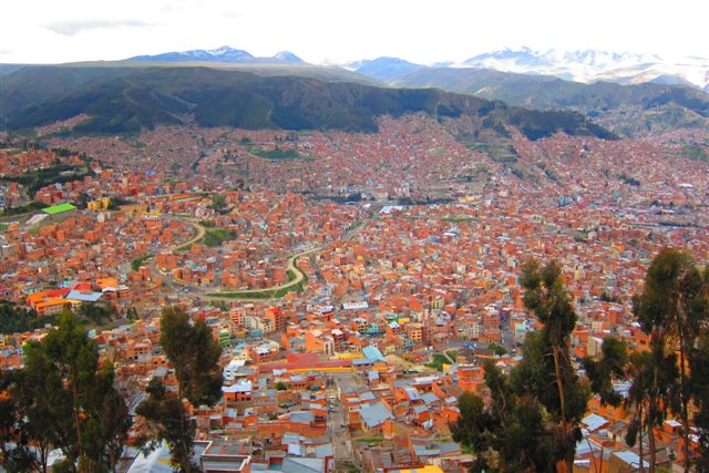
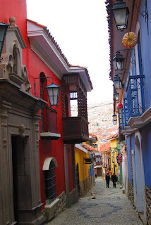
The journey from Copacabana to La Paz took a total of 5hrs with 3hrs on the bus because of the ferry crossing at San Pablo De Tiquina on Lake Titicaca. It is here that we farewelled the "Lake in the Clouds" to travel a further 112km inland to the "City in the Clouds", La Paz, officially the highest city in the world at 3,660m in the centre rising to 4,100m in the suburbs. La Paz is the largest city in Bolivia with 1.5m people and is the "Governement Capital" with Sucre as the official and "Judicial Capital". Go figure. Couldn't the Bolivians decide on one capital? Maybe the ozzies should have done the same with Sydney and Melbourne before Canberra came along! La Paz was founded by Alonso De Mendoza in 1548.

Our introduction to La Paz was spectacular. The bus travels on the flat, wide, "Altiplano" valley at 4,100m and then all of sudden, there it is! An entire city built in a narrow canyon, roughly 30km length by 12km width at a average height of 3,660m. The reason everyone fits is because every dwelling is at least a 3-storey block of units, built everywhere, even up absolute cliff-side faces! It is amazing! It is a smaller, compact, crazier version of Quito, only higher! La Paz, for this reason, is "geograhically" spectacular but is too crowded, too many vehicles, people everwhere, cars and vans all-over-the-place and very run-down and grubby! La Paz is not for the faint-hearted or elderly, it is full of very steep hills, choked with traffic and toxic diesel fumes!

We arrived at our La Paz hotel above Plaza San Francisco at 5pm, so decided to book optional tours for the next 2 days rather than crash or see the city. That night we did something out-of-the-ordinary for dinner - we went Indian, run by a Brit! Poonan and Jess could not help themselves. It was OK since there were no Papadums and very slow service!


The next day (16FEB), I set out on my first tour at 8:30am to trek and climb to the summit of Chacaltaya, a mountain in the so-called Andean "Royal Chain". After 2hrs we ascended past the 5,000m snow line and stopped at 5,317m. I am amazed that they drive these rickety mini-buses to such great heights over shity, muddy, rocky roads with streams in the middle and hugging cliff-top edges.


It is here that we all got out and trekked to my highest ever on-foot elevation of 5,482ft from 5,317m at the bus over 35min. At the top the view was spectacular and La Paz was obscured by cloud. It was at the summit, of all places, that I met Susan from Coogee in Sydney, who just a few weeks earlier had scaled the heights of Mt Aconagua Elev 6,962m, the highest mountain in Argentina, South America and in the world outside of the Himaylayas!

I couldn't believe it! There I was standing, breathing and beholding my own two feet on a snow-capped summit at 5,482m (17,986ft), almost 4,000ft above the oxygen line! I was in the heavens... as much as anyone could be! My previous record was 4,910m. Mt Chatalcaya is also the home of the highest ski run, from 5,320m to 4,900m. This was discontinued in 2005 because of insufficient snow. The locals blame global warming.

Our descent was very quick and before we knew it we were in the mini-bus and on our way back to visit the Moon Valley, 10km south-east of La Paz. The Moon Valley is actually a physical valley of very tall, erosion sculpted, pillars of beige coloured clay and dirt formed some 20-60 million years ago when Lake Titicaca was a vast inland sea. We spent an hour walking between pillars and climbing various pillars. These pillars are everwhere and in the outer suburbs of La Paz, giving it a spectacular appearance. These pillars resemble certain cliffs on the moon, hence the name.

That night I met Susan for dinner at a restaurant across the road from our hotel that she recommended for Llama. It was better than Alpaca - had a big slab of it, done on a hot plate. It was tender, salty and tasted like venison.

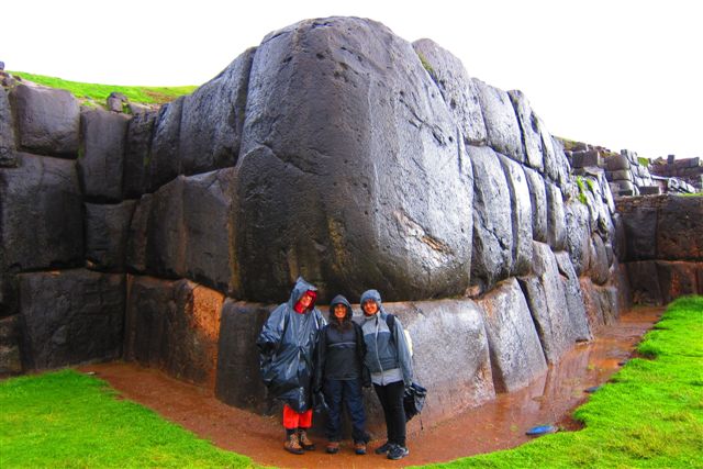
The next day 17FEB, Johnny Cloudrunner, turned into "Johnny Cloudrider" by completing a 55km mountain bike ride down a gravel road that is rated as the "World's Most Dangerous Road (WMDR)".

I did this as part of an optional tour organised by a company called "Gravity Assisted Mountain Biking" with Poonan and 9 other people from USA, Netherlands and NZ. This gravel road was built over 4yrs starting in 1937 between the towns of Unduavi and Yolosa, some 60km from La Paz to enable farmers to pick-up supplies. This road killed an average of 250 people per year, making it the most dangerous based on deaths per km per period.


What makes it particularly dangerous is the very narrow cliff-side twists and turns with no barriers, as it descends from 4,500m to 1,200m in just 48km. Huge trucks used this road making it worse. For this reason, a new road was started in 1997 and opened in 2007. The WMDR is now just used by bikers like us. Our biking started 15km further back from the start of the WMDR at an elevation of 4,700m. We cycled the first 7km in 20min in snow and freezing conditions. Unfortunately we got cold and wet so it was back into the bus for the next uphill 8km to the start of the WMDR.
We put on more dry layers of clothing and started the WMDR. It was spectacular, winding and twisting its way down cloud covered valleys and waterfalls. There was light rain the whole way and temp went from 10C to 15C. There were countless tricky bits and the bike rumbled over the gravel. The bikes were equipped with fluid driven disk brakes so slowing and stopping was a breeze. I nearly stacked it twice - once on a bend running close to the cliff wall and the other time when someone stacked it in mud right in front of me and I had to swerve suddenly to avoid them. It took me 90min to do the 48km over 3.5hrs of stopping and starting over "stages" to enable slower riders to catch-up. Once at the bottom we visited a UK run animal sanctuary (for injured wildlife) which offered us hot showers and a buffet lunch of vegies and pasta! After a few beers to celebrate we climbed aboard our van for the 3hr, 80km trip back to La Paz. Well worth the $110AUD we paid for this experience.

I suprised myself at 6:30am the next day, by completing my 10km run in the hilly streets of La Paz over 55 minutes at 3,660m, my second highest run. At 9am I set off to see the city sights. The central "Plaza Murillo" (the city's founder) has an impressive cathedral. The Presidential Palace (home and office) is next door andd the plaza is completely covered in pidgeons! I then visited the "Folklore Musuem" to get a feel for the indigenous peoples that lived and still live aorund La Paz, their textiles, cooking utensils and even dancing masks!

I then walked to famous "Witches Market" where you can buy indigenous medicines and the prized specialty of dried Llama fetus! Now that was one thing I was NOT game to eat!

From there I went to regular markets that sell so many things over such a tight space that you can hardly walk through the crowd. It is here I got "squirted", a scam were thieves squirt detergent in your face, expecting you to stop and wipe, whilst they pick-pocket you. I had read about this in my Lonely Planet so I did not stop and ran forward instead and got away with everything in-tact!

My final stop was the "Coca Musuem" that chronicals in absolute detail, everthing you ever wanted to know about the famous Coca Plant (Leaf) and what is Bolivia's major export crop. Refer some interesting facts below. I met Susan again for a second Llama dinner before leaving our La Paz hotel at 6:30pm for our 12hr overnight bus to Sucre, the capital of Bolivia.

NEXT BLOG: to cover visits to Sucre (Capital of Bolivia) and Potosi (Highest City in the World) on our way to the Uyuni Salt Flats due 25FEB.


ACKNOWLEDGEMENTS: 1) Thanks to Susan from Coogee in Sydney who took the marvelous shots on Mt Chacaltaya Bolivia and climbed the tallest mountain in South America, Argentina and outside of the Himalayas, Mt Aconagua Elev 6,962m. 2) Thanks to Phil and his team for guiding us down the world's most dangerous road without a single stack! Great guides and great bikes since 1998, "Gravity Assisted Mountain Biking" is the best way to go at http://www.gravitiybolivia.com/

PERU FACTS: 1) Fifth largest country of 12 in South America covering 1,098,580sq km (size of France and Spain combined). 2) Has the most peaks over 6,000m making it the highest overall country. Characterised by the "Altiplano" a high wide treeless valley-like plain with volcanic mountains on either side. 3) Pop of 9.8m, 95% Catholic, 60% indigenous Quechua or Aymara with infant mortality of 45 per 1000 (both the highest in South America). 4) Ironically the poorest and cheapest country in South America but is the richest in mineral deposits (mostly Lithium and Silver, then Gas, then Oil). Bolivia does not have the money or expertise to exploit minerals. Every time they try they are ripped-off, mainly by Chile. 5) First signs of humans in 1,500BC, then Aymara peoples from AD500 to AD900, then Tiwanaku peoples from AD900 to 9th Century, then Inca invasions to 15th Century, then Spanish from 1532, then independence on 6AUG1825 after 15yrs of bloodshed under General Antonio Jose De Sucre and Simon Bolivar. 6) Since indpenedence Bolivia lost 350km of Pacific coastline to Chile in the "War of the Pacific (1879-83), lost a huge chunk of rubber-rich Amazon land to Brazil and lost inland forest land and 80,000 lives to Paraguay in the "Chaco War (1932-1935)". 7) There have been 200 changes of Government between 1825 and 2010 including countless military coups during the 1980's. 8) World's biggest producer of Coca leaves and by-products but at one stage USA tried to shut it down since one by-product is cocaine. Bolivia battled this out and won! Current President Evo Morales has done much to preserve this industry and put it in the control of the indigenous peoples.9) Some prices: 625ml local Pilsener beer ranges from $1-2AUD, bread is $0.50AUD, restaurant main is $2-4AUD, sandwich is $1-2AUD.

COCA FACTS: 1) Bolivians, Peruvians, Equadorians (mainly farmers living above 2,700m) all chew the Coca Leaf to prevent altitude sickness, give them extra strength for work, reduce hunger, reduce pain and provide high source of protein and fibre similar to legumes and grains. 2) First chewed in 2,500-1,800BC since found with mummies. 3) Incas used it as anesthetic to remove brain tumors. 4) Huge source of cocaine, first extracted in 1885. Does not affect you when yoou chew leaves. 5) First used in Coca Cola in 1886. Still used now bbut with cocaine alkaline removed. 6) Catholic Church band it in 15th Century as a drug. 7) Henry Kissinger band it from import to the USA in 1971 but Bolivia fought to re-introduce in 1983 with cocaine alkaline removed. 8) Has twice the fibre of legumes.

STOP PRESS: Correction: the last post "Lake in the Clouds" covered "11-14 February 2011, Days 64-66 of 127", instead of 11-16 February as posted.

Wednesday, February 16, 2011

Lake in the Clouds (11-16 February 2011, Days 64-68 of 127)

Cuzco, Peru is the acknowledged capital of the Incas. The proof is in the ruins. Five big ones to be exact! Fri 11FEB was the day we visited all of them and were quite impressed with what we saw and learned.

Our tour started at 2:30pm with a visit to No 1 Qorikancha in the centre of Cuzco. This name means "The Temple of Gold" and the Spanish built a Dominican Monastery on top of this Inca site in 1535. The Spanish did this on purpose. Qorikancha was actually the "Mecca of the Incas"! Every Inca was required to visit this temple at one point in their life. The Spanish considered the Incas to be Pagans so they did their best to repress their religious sites.


But karma had its way. Three major earthquakes in the late 18th and early 19th centuries saw the Spanish buildings crumble and the Inca ruins remain. This is because the Spanish used square bricks and mortar while the Incas used trapezoidal granite blocks that "locked" together. This involves huge bolders with "steps" or "edges" and angled sides that prevent one block from sliding over the other. The former crumbled and fell while the later just shifted with gaps but stayed upright! That did not stop the Spanish from nicking 150,000 tons of Gold and 16 million tons of Silver from Peru to Spain during their occupation.

The next stop was No 2 Saqsaywaman (pronounced "sexay waman") at elevation 3,600m and the best preserved of the 6 ruins. This huge site is 2km from Cuzco and is an Incan Royal Residence and symbol of power to enemies since was built from huge granite blocks ranging from 30 to 180 tons over 3 levels as if to say: "don't f**** with us!!! The photos you see in this post only show 20% of the total structure that survived the Spanish occupation.


No 3 "Tambomachay" at 3,765m and 11km from Cuzco, was our next stop which was the Incas ceremonial bath with water still flowing but not many structures still standing. Very close was No 4 "Pukapukara" which means "red fort" but was actually the alledged royal Incan "hunting lodge"!!! It overlooks distant valleys and mountains to the east of Cuzco.


The final, No 5 site was "Q'engo" which means "zig-zag" and is a massive limestone rock (as big as small house), the interior of which was carved out of a single massive boulder by the Incas as a place of sacrifice, featuring an altar, seats and even a sky-light so they could see what they were killing!

That night, Maureen and I enjoyed Alpaca done medium with pepper sauce in a slightly "fancier" place and it tasted like beef!

The next day on 12FEB, we farwelled Cuzco at 8:30am for a 5hr double-decker bus ride to Puno on the eastern side of Lake Titicaca, the highest lake in the world at 3,809m (12,497ft, only 1,500 ft below the oxygen line) - literally a "lake in the clouds"!!!

It is in Puno (Pop 178,500. Elev 3,860m), that John Cloudrunner broke another high altitude run record, not once but twice.


Two 10km runs along the lake at 3,809m (12,497ft), one on 12FEB and the other 14FEB. Runs were harder than Chivay (previous record of 3,651m) with 52min and 55min to do 10km and some pain in right foreleg on second run. Nevertheless, I was thrilled to run the highest lake in the world and do it twice! The runs where along the Titicaca shore-line. the first with plenty of sun and granny-smith crisp weather, sky so blue, water deeper blue and visibility unlimited!

The bad news about being in Puno was the need to fix my laptop which went belly-up on the 5hr bus ride from Cuzco to Puno when Windows refused to re-start during a battery change. The good news is that I managed to find a place in Puno to fix it two days later - read all about it in LAPTOP DRAMA below.

At 7am on Sun 13FEB we set out from our Puno hotel to spend the next 2 days on Lake Titicaca with an overnight stay with an indigenous faqmily on one of the islands.

Lake Titicaca is the highest lake in the world at 3,809m (12,497ft) and covers an area of 8,560sq km, almost the size of Switzerland! At an average of 165km by 60km, maximum depth of 600m, average temp of 9C in summer and 2C in winter, it is more like a freshwater sea. The lake was central to Inca culture, being the bithplace of the Inca Sun God.


Our first stop on our Titicaca adventure was a visit to one of the 50 "floating islands" of the local Uros peoples, some 10km offshore from Puno but still in Puno Bay.

These peoples decided to build floating islands from the native "reeds" in the lake to avoid the aggressive attacks of the Incas pre-15th Century and the sackings of the Spanish post this period.

They continue to this day!

There is a total of 3,550 Uros left living on these islands with 4 schools and 3 churches to boot! Our tour group of 25 visited 5 families living on a single island and they explained to us how they built it, how they maintain it (reeds must be replaced twice a year) and what they eat and make. This is not a place for the very active but the absence of stress means they can live to up to 75yrs old which is a lot for a local.

Next stop was Amantani Island (Pop 4,500. Max Elev 4,145m. 38km from Puno) where we would stay the night with a local indigenous family descended from the Tiwanaku culture.

It takes a boring 3hrs to sail the 30km from Uros since the boat is old and has a piss-weak engine with max speed of 10km/h!

Once there, each of the 25 gringos were split amongst 12 families making our experience very intimate and authentic.

Maureen and I met Senior Ricardo at the wharf, who walked us to his humble abode up in the town plaza, some 15min walk, 30m uphill! Although Maureen had a hard time walking up we both delighted to find that Snr Ricardo was the towns publican running a cute pub with plenty of beer! Trust the only two ozzies to be assigned to the pub owner!!! We then met the very short and moon-faced Seniora Francesca. A lovely lady with rosy-red altitude cheeks and lots of colourful layers of traditional skirts. She looked like a walking onion! Our hosts have 6 children ranging from 30yrs to 13yrs with 2 at home and Snr Ricardo is 70 whilst seniora is 64. How do they do it?

After a lovely home cooked lunch of Quencha soup, "haloumi-style" fried cheese, tomato and YES, more potatoes, I set off to the beach for my swim in the highest lake in the world, I wanted to do 30min but could only manage 5min in the 9C water before my heart felt it would jump out my chest and my head explode!

At 4pm all the families brought their gringo guests to the town square and we set off to walk to Mt Pachatata (Elev 4,050m) and Mt Pachamama (Inca for "mother earth", Elev 4,145m and this highest point on the Island and in all of Lake Titicaca).

The views from both were spectacular and the hike up was good for me but not for some due to altitude sickness. Lake Titicaca has simply the best clouds I have ever seen, especially when sunny - the lake is so high that the whispy alto-cirrus and thick alto-cumulus clouds at 20,000ft are right there above your head and just look spectacular!

We got back at 6pm and had a lovely beer on our home-stay balcony overlooking the lake.

Dinner was very simple comprising a potato-thickened vegie soup and a tomato/herb/potato omelette.

I also shared my red wine in the yogurt container with our hosts and they loved it. Before you say "salute" (cheers) and drink, you must pour a smidgen of your drink on the ground to "pachamama" or mother earth so she can return the favour 5-fold!

Our hosts simply loved the wine and gobbled it down, especially the seniora! I was starving but too shy to ask for 5 more omelletes! Instead I relied on my own stash of two museli bars and a packet of crackers that I bought from Snra Francesca and gobbled up late at night with a beer for good measure!


Our lovely couple then dressed Maureen and I in traditional costume and walked us to the local hall for a Peruvian dance with all the other gringos (our tour group) and their host families. We had a great time dancing and drinking 625ml beers for only $2AUD! Snra Francesca was particularly keen to get us dancing and threw us around like coca leaves! I slept like a baby that night.

The following day we woke at 7am after a night of heavy rain and enjoyed a breakie of corn pancake and coffee. After thanking Snra Francesca and greeting her 1yr old grandson baby boy "Sebastian", Snr Ricardo walked us down to the wharf to meet the rest of our tour group and set off on a 1hr sail to nearby Taquile Island (Pop 2,500, Max Elev 4,015m. Area 7sq km).

The boat trip to the island was horendous for many, rolling around in a 2m swell!

Taquile Island is UNESCO protected because it produces very unique, hgh quality fibres, that women spin while walking and wait for this.... from which the MEN (yes MEN) knit and weave high quality clothing in the traditional Tiwanaku style. UNESCO has decided to preserve this tradition.

We walked 1hr and ascended 209m from the port to the town square under occassional showers.

As soon as we got to the town square it poured meaning we would not see the "weaving men" who actually knit outside and as they walk around.

Instead we visited their co-operative to see their finished products which were very colourful and varied in design.

We also found out that single men wear a red hat and married me wear a red and white hat. When men get engaged they have to weave the bride's wedding dress! No wonder there were so many red hats in the town square!!!

Poonan, Jess and I then decided to head back to the boat down 500 steps insead of lunching with the others at 11am. By 12:30pm we were on our way back to Puno, another 3hr cruise which I slept most of the way.

Once back in Puno I completed my second record-breaking run and picked up my repaired laptop.


It was then off to a local restaurant to have Guinea Pig, Peru's specialty!!! You need to order the Guinea Pig ahead of time when you book the restaurant, because they kill it 1hr before you arrive and prepare it for cooking when you arrive. The little critter is flash-fried then finished in the oven and usually served with local potato and large white corn. It tastes like a cross between turkey and duck believe it or not. A lttle rich, not much flesh but filling because of the mini-crackling skin. Another local animal bites the Golfin dust!

NEXT BLOG: to cover our entrance into Bolivia form Peru and La Paz (the capital) due 20FEB.

ACKNOWLEDGEMENTS: 1) My sincere thanks to "Pomme Peru" (Apple Peru) computer store in Puno for their fine work in recovering my data and fixing my laptop. All this for 50 Soles ($47.25AUD)!!!

LAPTOP DRAMA: I had my first laptop failure in the 5hr bus trip from Cuzco to Puno. I had just finished writing my Machu Picchu blog about 1hr before Puno (spent 4hrs writing it) when I got the low battery warning, so I decided to save to disk and shut down to change battery before backing up to stick.

To my horror, after changing the battery, Windows refused to re-boot citing a corrupt config.sys file in thesystem32 directory and asking for a reload from a system disk that I did not have. I had just lost 4hrs of blog that I wanted to post that night from Puno! I was heart-broken. Not only would I have to re-write it but my laptop was dead and inaccessible. Lucky for me, our guide and I managed to find a computer place, cheekeley called "Pomme Peru" (Apple Peru) after arriving in Puno and they were able to access my data via another PC.
They then asked me to leave the laptop with them for a day since they suspected a bad hard disk. Lucky for me I was off to the Islands on Sun 13FEB returning Mon 14FEB so I left it and came back Mon arvo. The cause of failure was a virus that polluted several windows files. He reformatted the disk and loaded the latest WIndows XP Professional, Microsoft Office 2007 and ESET NOD32 antivirus software. The only downside is that it is now slower (heavier software than before) and all in Spanish!!! Maybe this is the best way for me to learn Spanish! Despite the happy ending, I had to post my Machu Picchu blog from the hotel machine from the data that my man in Puno had recovered. Yet another set-back overcome!!!

FACTS: 1) Indigenous people in Puno and around Lake Titicaca are darker and shorter with longer eyelids and larger (hook) noses because of the higher altitude and more sunny days. 2) I forgot to include the following in my Machu Picchu blog so I attach them now: a map of our Lares Treck and a map of Machu Picchu and what we saw in detail that day.

One of my mot favourite photos is the one on the left here... It is a moonlit night of Lake Titicaca under moon and Venus on the night we danced with the locals...I went out for a break...and saw this....what a moment...thanks S95 and Tv timed shutter exposure!

PS: Venus is the dot in the middle of this grand photo!