Te Pito O Tehenua. Rapa Nui. Isla De Pascua. Easter Island. Four names. One place. The most isolated place on Planet Earth! Why? Because the people living on this island, past and present, are further away from any other human being living in a town or city or village in any other place in the world. Chile is the closest at 3,700km and Tahiti is 4,000km away. This is the 14th and last "Superlative" that I visited in South America. My last official site before flying home to Sydney.
This place is also special because of the giant stone "Moai" statues and the captivating story of who built them and why. Here is a summary for those of you who have no time but want to know the truth!
Unfortunately it was not aliens! I came here just to make sure.
Easter Island was first inhabited in 400AD by the "Handu Eepe (Long Ear)" peoples travelling here on raft-like boats mae of tree trunks from the Marquesas Islands in French Polynesia.
They originally called the island "Te Pito O Tehenua" meaning "The Navel of the World" to suggest its isolation and its "umbilical" link to Mother Nature's source of natural healing energy or "Mana". Believe me - I did not make this up. It is not my style.
Apparently there are 3 other such energy sources on Earth and one of them is Delphi in Greece!
In 600AD a second wave of immigrants called the "Hanau Momoko (Short Ears)" arrived from the Mangareva Islands in French Polynesia.
The Long Ear peoples decided to let them stay but only if they "worked for them", a euphemism for slavery!
The Long Ear people lived in distinct "tribes" all over the island, each with a male "chief" who's primary job was to protect the village.
When they died, their eldest son took over - a type of royal succession, if you will.
The chief was buried under a flat, rectangular shaped platform of volcanic rocks called an "Ahu". There are 250 of these on the island.
Now here is the moment of truth!
In order for the village to continue to be "protected" until the son chief came up to speed and to endow him with the protective talents of the father chief, a "Moai" was erected on top of the "Ahu" to protect the village.
This is a direct carry-over from what the Long Ear people used to do in French Polynesia using "Tikis" which were smaller ("Tikis" were also used as good luck charms by the Maori's and native Hawaiians).
So essentially, the Moai are giant stone Tikis or protectors with long ears!!! Not Gods. Not epitaphs of dead people. They are not meant to look like the chief or anyone else. They are not meant to be unique in features.
Each time a generational chief died, he was buried on the same "Ahu" but in another layer on top of the old one and another Moai was erected to continue his protective power over the tribe.
The Moai typically faced the rising sun but some faced specific constellations or the village they protected.
The Maoi had "eyes" made of coral painted with red lichen. This channelled the protective "Mana" energy to the tribe for protection.
The Moai also had "topnotch hair" which looks like a big red hat. This is called a "Pukao" and 700 of these were made.
The only problem here was that the Long Ears got the Short Ears to build and erect all the Moais. The Short Ears did this from 800AD to 1600AD which was the "golden years" of prosperity for the Long Ears on the island.
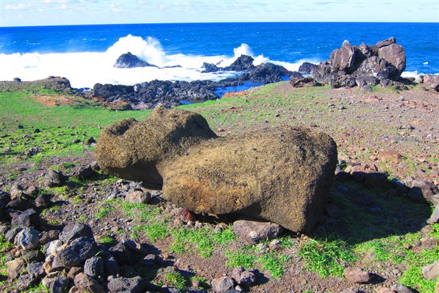
But at 1-2 years for each Moai, this eventually drove the Short Ears to revolution from 1600-1800AD and they ended up tearing down every one of the 400 Moai they had erected on every Ahus.
The Moais were brought down face-down so that the eyes could roll out and be collected and destroyed by the Short Ears to eliminate the protective energy.
Out of 800 eyes only 3 remain. Two are in a musuem on the island (I saw one) and the other in Norway (stolen by a visitor!).
A total of 900 Moais were carved. 400 were erected and 500 remain in the quarry of their construction (Volcan Rano Raraku - featured below).
On Easter Sunday in 1722 the Danish Admiral Roddeveen was the first white-man to set foot on the island and called it "Easter Island" to commemorate the landing date.
The Danes did not bother claiming the island because it was too small, too remote and had no gold or oil.
Even Captain Cook visited the island in 1774 and sailed on for similar reasons.
The French then arrived in the early 1800s and renamed the island "Rapa Nui" meaning "Big Land" after hearing the locals tell their tale of how they sailed from a "small" French Polynesian island to a "bigger" version. This name stuck.
Believe it or not, a French businessman bought the entire island in the mid-1800's and rented it out to a huge Scotish agricutural company to farm sheep and cattle. He finally sold to the island to the Chileans in 1888. In 1955 the Chilean government, realising the enormous value of the Moai started re-erecting them and now approx 50 of 400 stand tall again!
What a history - and you can see all of the above including ruins of Ahu and Moai everywhere on the island. UNESCO was so impressed that it issued protection in 1995 and now most of the island is one big National Park (Parque Nacional Rapa Nui).
At the moment, approx 70,000 visitors visit the island each year. For more details on the geography and peoples of Easter Island refer to "RAPA NUI FACTS" below.
My journey from the hotel in Rio De Janeiro to the hotel in "Hanga Roa" the only town on Easter Island, took a total of 26.5hrs, 10hrs of those in the air. I had to stay overnight in downtown Santiago because of connections. I left Rio De Janeiro at 11am (Sat 9APR) after my 4th and last morning run on Copacabana Beach and flew to Santiago via Sao Paulo (4.5hrs flying). My flight from Santiago to Easter Island left at 9:30am the following morning (Sun 10APR) and took 5.5hrs. I watched 3 movies including "Vantage Point" with Dennis Quaid which had more twists and turns in it than a lock of Shirley Temple's hair - what a story and brilliantly executed. Everything about the flight went smoothly and on-time. A first for me in South America.
Easter island airport runway is actually the longest in South America since NASA extended it to 4km to enable the Space Shuttle to land in case of emergency - it is the only one in the Pacific.
Easter Island is shaped like a triangle, 24km along the base with sides of 17km and 16km to measure 173 sq km (One-third the size of metropolitan Sydney). It has a sub-tropical climate and is like Fiji or Hawaii but without the Palm Trees or lush green vegetation. Even in April (late Autumn) it was warm (20-27C) and the water a great 22-24C and greeny blue at shore. Only LAN Chile flies here twice a week using a big Boeing 767-330ER (250 people).
My first impressions of Easter Island were how colourful it was. I was expecting a cool to cold, Lord Howe style windswept island but instead I got a warm, sunny place with very few trees but green grass and greeny blue water with deep blue further out. It is sub-tropical, similar to the southern Queensland coast.
The local "Rapanui" have the look of Pacific islanders rather than Chileans and remind you of the Maoris or even the Tahitians. After dumping my gear in my room at 1:30pm (Sun 10APR) I grabbed my camera to photograph the only town and orient myself.
Hanga Roa (Pop 4,400) is the only town and powered by several huge diesel generators next to the airport.
There are houses in other parts of the island bringing the population up to 5,000 but these have no power or running water or sewerage. Approx 3,000 are descended from the Long and Short Ears and the rest are mixed with some pure Chileans who have moved here because of tourism.
The town itself is very spartan and looks like a town in Papua New Guinea! The harbour is nice with boats and seafood restaurants.
There is a Port that receives containers every 3 months (11 days sailing from Chile) but most perishables come in by aircraft. The coastline around Hanga Roa is just awesome. Huge deep blue waves crashing on black volcanic rock!
This was a tease - it took me minutes to start running in this place. After my first run, I walked 20min at 7pm to my first Moai at "Ahu Tahai" just outside town. By 8pm the sun was down and I was in a spell. Moai and Sunset - what a combo - see for yourself in this post. I had dinner in the main street with a bottle of Argentinian 2007 Reserva Tempranillo and listened to native Rapa Nui music which is very similar to Maori music of New Zealand. Lots of male-female harmony to guitar and light percussion. I went down like a stone Moai in my room that night!
At 10am (Mon 11APR) a van with 15 other gringos pulled up to the hotel to take us on a full-day tour to the "serious" Moai and Ahus on the other end of the island.
Being such a small island we arrived at our first stop at "Ahu Akahanga" within 20min and inspected the Ahu with the most number of burial layers (hence buried chiefs). This place is very important since it contains the remains of the first chief, "Hotu Matua" who led the first landing in 400AD and is considered the "father" of the Rapanui peoples.
The only i-ss-i-u (issue) with this Ahu was that all the corresponding Moai were collapsed. These were not raised here in recognition of the "revolution" of the Short Ears which apparently began here! This place also contains many "Umu Pao" or "earth ovens" similar to the ones used by Maoris to cook the Hungi.
Next stop was "Volcan Rano Raraku" which is an ancient lake-filled volcanic caldera featuring the "Volcanic Tuff" rock quarries from which 90% of the island's Moais were literally carved from the sides of the volcano in one piece and transported to the Ahus all over the island.
The most popular theory of transportation was face-down using two criss-crossing layers of tree trunks. The top row at right-angles to the Moai to support him face-down and prevent his "big shnoz" from damage, whilst the bottom row at right angles again to serve as "train tracks" to roll the top-half along. This theory is supported by approx 60 Moai which can be seen lying face down in a trail from the volcano to the coast.
Upon arrival at the Ahu, ropes of reed (from volcano caldera lake) were used to hoist up the Moai and pile rocks underneath until upright. Easy. Rubbish. There must have been aliens involved!!!
The use of tree trunks to transport 400 Moai over some 1,000 years took its toll on the trees of Easter Island and that's why Europeans found it bare!
We saw large sections of the volcano still containing half carved-out Moai. The Rapanui used the harder basalt rock to carve the figures literally out of the mountain side in one piece. The biggest Moai on the island is one of the unfinished carvings estimated at 180 tons! We then trekked to the inside of the caldera of Rano Raraku. It was filled with water and contained growing reeds used to hoist the Moais. There were also many (approx 15) Moais still standing, spread out on one side of the crater.
A simple lunch was served in a foil "tray" at the bottom of the volcano and then it was off to nearby "Ahu Tonganiki" to see 15 Moais standing next to each other! It was clearly the best example of Ahu and Moai we have seen and these are very famous.
This Ahu has several generations of chiefs buried in it (hence the 15 Moai) because it belonged to the biggest and most prosperous tribe, located between Volcan Rano Raraku and the ocean - this tribe controlled the quarry.
In 1960, the world's strongest earthquake (Richter 9.5) hit Chile and caused a huge tsunami which hit Easter Island and collapsed and moved the 15 Moai more than 300m. Thanks to a Japanese heavy engineering company, they were re-erected between 1992-1996.
Stop number 4 was "Ahu Te Pito Kura" by the ocean on the other side of the island.
This Ahu had the tallest, heaviest Moai to be transported and erected - 10m tall and 80 tons in weight (plus 12 tons of stone "hair" or Pukao). It was also the last Moai to be toppled in the revolution in 1838.
This is also the sight were the French explorer "La Perouse" landed in early 1800 and YES, it is the same guy that sailed into Port Botany, Sydney!
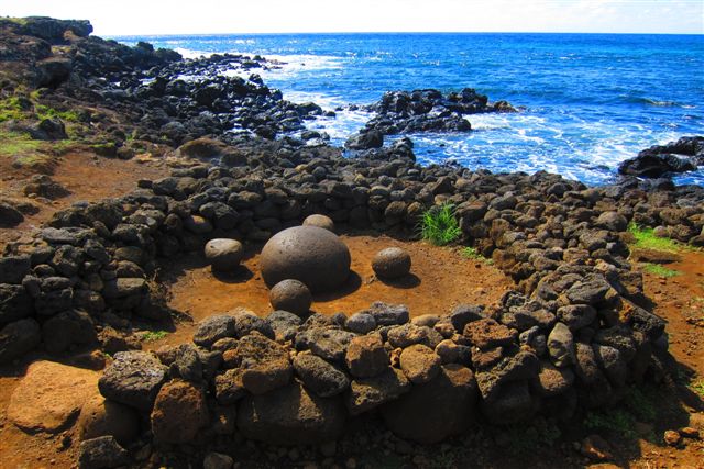
Next to the big fallen Moai is a circular stone fence with a naturally formed smooth rock in the middle that looks like a polished giant egg surrouded by 4 smaller eggs that look like seats.
This is the "Navel of the Earth" and the alleged source of "Mana" energy according to the Rapanui people.
Our final stop was much welcomed - "Anakena Beach" - a postcard perfect aqua-green, waveless bay with white sand, palms and even 5 Moai of its own!
This is the beach where the Long Ear peoples first landed in 400AD. This place was also my first 1.5k swim off the island and I loved it.
From here it was 16km back to town (total touring today of 45km and 8hrs) and a bottle of Botalcura Estate Gran Reserva Carmenere 2007 from the Valle De Chile - very peppery with loads of fruit and oak well integrated together - Chile does the Camenere grape very well.
I enjoyed this wine as I blogged and when 7:30pm came around I was off to another Moai sunset, still close to town, along the west coast beyond the cemetery but a bit further up from yesterday - "Ahu Vai Uri" which has 4 Moai.
I sipped on my Camenere as I waited for a completely cloudless sunset - quite different from yesterday. I dined at the same place as yesterday since they let me drink the rest of my wine for free - I guess I started BYO on Easter Island.
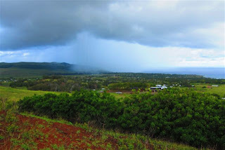
It had rained a little overnight when I awoke at 7:30am on Tue 12APR for my run. I even got a little spray on my way back but was still enjoying the calm, still day-break with great big columns of cloud all around me offsetting a very green set of hills. We were off in our tour van again at 9:45am with the same group of people for two separate tours, AM and PM.
The first AM stop was "Ana Kai Tangata" which is a sea-side cave containing paintings of "Manutara" or Sooty Tern birds that were part of a special "contest" to select the King of the island way back from the 1500s to 1867 (more on this later). The cave was also used by the locals to hide from invaders.
Second stop was the ancient ruins of the "Orongo" village set atop the rim of the caldera of "Volcan Rano Kau" some 300m above sea level.
What a site.
The Rano Kau volcano erupted some 3 million years ago and left a massive 1.6km diameter caldera, complete with lake to 30m depth.
There is a swamp in this lake with many species of water plants and a variety of tropical vegies grown by the locals along the shore like avocados and mangoes. Together this mini ecosystem has its own micro-climate and shows up colours and textures that are a photographers dream.
Very dramatic.
The ancient settlement of Orongo consisted of 54 houses built with shale, close to the ground to counter the constant high winds of this area.
Many of these have been restored and the view out to the Pacific is breathtaking. It is the one place where you are physically reminded of Easter Islands isolation. Deep blue Pacific everywhere with fluffy clouds touching the horizon.
Orongo village was ceremonial, used only once a year in the beginning of Spring to host the annual "Tangata Manu" or "Bird Man" contest to select the King of the island from amongst all the tribal chiefs.
To become King, the competitors had to swim 1.5km offshore to a rocky outcrop (visible from the village) and be the first to find and bring back the egg of a "Manutara" or Sooty Tern.
Many died doing this (some by shark attack) but the winner lived in extra luxury for a year. This contest was also linked to the "Bird Man Cult", a type of religion practiced by the Rapanui, involving mutliple gods with "Make Make" the god of creation, as the Zeus!
After some fine shots of the main town of Hanga Roa we dscended to our third stop at "Ahu Vinapu". This site comprises two platforms right next to the start of the island's runaway. The first is the most architectually precise of any on the island - it has huge stones that fit together perfectly and all pre-Inca! The second contained Moais wearing the red "Topnotch" or hair. All Moais are collapsed in the two Ahus. These two also have the preserved "crematoria" since tribal commoners were cremated. This is another reason Easter Island ran out of trees under the Rapanuis.
By 1pm I was back at the hotel and went for my second 1.5km swim at Hanga Roa's Port since it was clear and calm. After a brief rest it was back in the van at 3pm for our final afternoon tour.
First stop was "Puna Pau", a big hill and
quarrry composed of "Hani-Hani" or Red Scoria, a bright red stone that was used by the early Rapanuians to make the "Pakao" ot Topnotch hair of the Moai.
You can see many semi-carved and abandoned samples here - think of it as a huge Moain barber shop! Bah ah! The view of the main town of Hanga Roa is also great from here.
"Ahu Akivi" was next with its proud 7 standing Moai all looking out towards the western coastline and facing exactly in line with the setting sun during both equinoxes. These 7 Moai represent the 7 young sailors that Hotu Matua (Rapanui patriarch) commanded to explore the island after the first landing in 400AD.
Third and final was "Caverna Ana Te Pahu" which is the largest system of underground caves on the island formed by a lava flow plug during the first eruptions. The system is so well protected that it has its own micro-climate so the first Rapanuian chiefs grew Banana Trees here to sustain their flock when they hid from invaders. For this reason it is also known as the "Banana Caves" by today's locals. The banana trees are still growing here and the walls of the cave contain many multicoloured mosses and lichens which only a camera can see.
What a day.
I have seen 37 of the 50 Moai and been fascinated by its history and peoples.
By 6pm I was back in my room sipping La Joya Reserve Syrah 2009 from the Colchagua Valley in Chile whilst writing this last active post!
At 7:30pm it was off to dinner. My last meal and night of Ai Caramba 2011! I chose a little restaurant overrlooking the sunset next tot he town cemetery and what a show.
Probably the most spectacular sunset to date given the recent rain and myriads of clouds hugging the horizon and causing splashes of pink and purple to light up the sky!
To top it off, the restaurant even played a Greek track!
My walk back to the hotel was very contemplative as I raced through the myriad of experiences, landscapes, peoples, meals and wines that I had consumed over the last 125 days.
I could not believe it was over. No regrets. To plan. The best. All I could do as I lay down to sleep was think of home.
Easter Island. Magic. One big outdoor archaelogical island musuem telling its story through the Ahu and Moai. The Navel of the World!
NEXT BLOG: is the last one, to be called "Best and Worse" covering the journey home and summarising the best and worse of the entire journey including key overall ACTUAL statistics. It is due for posting from Bondi Beach, Sydney on Friday 15 or 16 April 2011.
ACKNOWLEDGEMENTS: 1) My sincere thanks to Melissa from Brisbane for her patience and great results in taking the "Maoi Shots" and "Moai Ozzie Dag Dances". 2) Many thanks to the manager of Chez Joseph, Manuel Alexandro Tarias Mardones, who provided me with tons of info, native Rapanui music for the film and my two boarding passes to take me to Bondi! Look him up at http://www.hotelrapanui.cl/